![]()
![]()
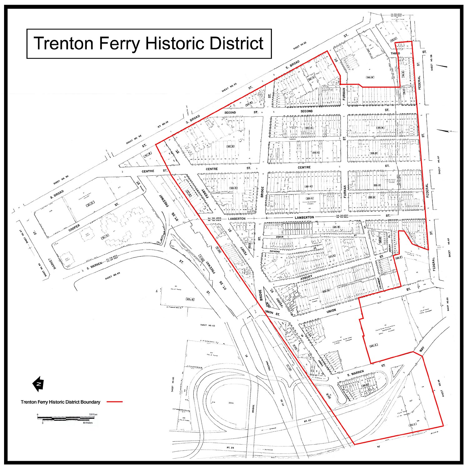
(click on map for larger image)
TRENTON FERRY HISTORIC DISTRICT NOMINATION (DRAFT)
The Trenton Ferry Historic District, in the City of
Trenton, Mercer County, New Jersey, is an urban mixed use neighborhood composed
primary of modest working class row homes and duplexes, commercial buildings,
school buildings and churches. Although
significant ties to the districts 18th century past survive, the vast majority
of its historic resources date to the 19th and early 20th centuries and relate
to the period of the City of Trentons greatest urban and industrial expansion. Consistency in scale, massing, form and materials
has led to a diverse yet cohesive collection of buildings that together form
rich streetscapes and give the district a unified architectural character.
With only a handful of modern intrusions, the Trenton Ferry Historic
District readily coveys its historic significance and represents an important
aspect of the City of Trentons urban fabric.
The architectural character of the district reflects
the diverse and complex nature of the neighborhoods history. The majority of the building stock falls within
the National Register of Historic Places architectural classification categories
of Mid-19th Century and Late Victorian. Less numerous are buildings best
classified as belonging within the Colonial, Early Republic and Late
19th and 20th Century Revivals categories. Although design elements that relate to the Greek Revival, Gothic
Revival, Italianate, Second Empire, Queen Anne, Colonial Revival and even
the Spanish Mission Revival can all be found within the historic district,
Mid-Atlantic vernacular urban building tradition played a larger role in defining
the character of the districts streetscapes than architectural trends of
the moment. The relatively modest
nature of so much of the housing stock further emphasizes the significance
of the vernacular. Constructed to
house Trentons working class, most of the residences are relatively restrained
in terms of their architectural ornamentation.
There has been widespread loss of superficial exterior
details and many of the buildings have been aluminum or vinyl sided, but the
essential vernacular features of the Trenton Ferry Historic District including
historic massing and fenestration patterns and intact streetscapes, all remain
unchanged. Largely shaped between
the years 1704 and 1938, the urban landscape of the Trenton Ferry District
is the complex end product of nearly a quarter millennia of human environmental
evolution. Contributing resources
survive from every period of the districts history and it is this diverse
mix that gives the district its rich architectural character. With that said, although the Colonial and Federal
Period history of the Trenton Ferry Historic District is interpretable within
the urban landscape, the district most clearly reflects a time when Trenton
was an important industrial center and offers a window into the lives of the
citys working class
the millworkers and laborers upon which the citys economic
success was so firmly founded.
Within the 70 acre historic district there are approximately
879 individual parcels. On these properties
there are 582 contributing buildings (one of which is individually listed
on the National Register of Historic Places) and three contributing archaeological
sites. There are 73 non-contributing
resources. The majority of non-contributing resources are buildings constructed
after the close of the historic districts period of significance.
Many of these are outbuildings, typically small garage buildings fronting
alleys. A relatively small number of the non-contributing
resources are historic buildings which have been modified to the extent that
they no longer possess the ability to convey their historic character and
significance. Of the buildings identified
as contributing to the significance of the historic district, 415 or approximately
71 % were identified as having been constructed in the 19th century.
165 or approximately 28% of the contributing buildings were constructed
in the 20th century and only less than 1% were identified as dating to the
18th century. All three archaeological
sites were identified as being historic archaeological sites. One site is associated with 18th century historic
contexts. A second is associated with
18th and 19th-century contexts and a third relates to the 19th century industrialization
of the area.
The Trenton Ferry Historic District is roughly bounded
by South Broad Street, Federal Street, the Pennsylvania Railroad embankment
(now Amtraks Northeast Corridor) and the Delaware River. Various properties along the edges of the district
have been excluded due to loss of integrity or demolition. The area so defined reflects the waterfront
core of the Trenton Ferry Plantation, a historically significant 18th century
land holding. The Districts street
pattern is the product of competing 18th and 19th century influences. The alignments of Ferry and Broad Streets reflect
pre-urban roadways and cut at sharp angles to the system of city blocks later
overlaid atop the landscape of the Ferry Plantation. In type, scale and prominence, the buildings
that line these two roads reflect this fact and the enduring importance of
these routes as urban thoroughfares. Bridge
Street, although of later date, also belongs within this group of roadways.
Laid out in the opening years of the 19th century in connection with
construction of the first bridge across the Delaware River at Trenton, Bridge
Street came into existence before the Trenton Ferry Historic Districts city
grid was fully developed and initially functioned more as a local/regional
transportation conduit than a neighborhood street.
In the eastern part of the district, a relatively rectilinear
street grid is established by the generally north/south alignments of Lamberton,
Centre and Second Streets and the roughly east/west alignments of Bridge,
Furman and Federal Streets. The street
pattern in the western part of the district, defined by the generally north/south
courses of Warren Union, Asbury and Daymond Streets, is more irregular.
The north/south streets in this part of the district do not parallel
those in the eastern section nor do they directly correlate with street alignments
in other adjacent areas. The street patterns divide following the alignment
of the former Trenton Water Power Canal, which was in-filled during the early
20th century and overlaid by Power Street.
The Trenton Ferry Historic District is situated on
the eastern bank of the Delaware River and its physical relationship to river
is important to a fuller understanding of its early history. N.J. Route
29 runs through the extreme western end of the district. The construction of the street/highway known
at various times as Commercial Avenue, John Fitch Way and now N.J. Route 29 occurred in stages from North to South
over the course of the 20th century and, within the district, required the
removal of approximately twenty buildings along Warren and Fair Streets dating
from the 19th and early 20th century.
During the early 20th century, most of the Trenton
Ferry Historic District waterfront was occupied by the Trenton Municipal Wharf,
a complex that included a large warehouse/terminal building, turning basin,
bulkhead and wharf. The terminal building
was removed in the first half of the 20th century but portions of the concrete
wharf and bulkhead remain. Although
N.J. Route 29 represents a substantial
barrier between the waterfront and the rest of the Trenton Ferry Historic
District, the relationship between the western terminus of Ferry Street and
the riverbank still remains visually clear and is important contextually to
the historic integrity of the district. The alignment of Ferry Street between the Delaware
River and South Broad Street is probably the single most important tangible
link to the pre-urban history of the Trenton Ferry Historic District.
The alignment of Ferry Street is one of the earliest roads in the city
of Trenton and has remained a constant for over three centuries.
The earliest known map representing Ferry Street dates to 1714 and
shows the roadway following its present course.
Although later 18th century maps would seem to indicate a no longer
extant dog leg in the western section of the road, careful examination of
the maps indicates that the Ferry Wharf was always at the location of the
modern day foot of Ferry Street indicating that the course of the early transportation
route was actually the same as the present Ferry Street alignment.
Other resources that contextually relate to the Trenton
Ferry Historic Districts 18th and 19th century significance as an important
transportation corridor are the Ferry Plantation Archaeological Site (28-Me-93)
and the Ferry Tavern and Eagle Tavern sites. The Ferry
Plantation Site occupies the northeast corner of the intersection of Ferry
and South Warren Streets. Preliminary
archaeological investigations undertaken on the site in 1979/1980 identified
the buried remains of the Beakes House, the primary dwelling house of the
Ferry Plantation which was constructed c. 1704 and burned c. 1777. A total of thirty-three
8-inch diameter auger holes and 6-inch diameter posthole shovel tests, three
shovel probes, and eleven test excavations were employed to define and sample
the site. These investigations identified a rectangular feature approximately
19 x 246 extending to the depth of approximately 44 below present grade
that was interpreted as the filled remains of a cellar hole. The site has the potential to provide significant
information concerning early colonial lifeways in Trenton, the formation
and expansion of a main terminus on the early transportation corridor linking
New York and Philadelphia and the lifeways of a ferryman and tavern-keeper
in the mid-eighteenth century.
[1]
[1] Kalb et al. 1982: 17.
On the southeast corner of the same intersection is
the location of the Ferry Tavern or Ferry House. Appearing on several historic maps and believed to have been constructed
prior to 1754 and demolished between 1870 and 1882, the Ferry Tavern was one
of the most noteworthy establishments of its type on the colonial overland
route between New York and Philadelphia. Known during the 19th century as the Jenny
Lind Saloon, the tavern continued to operate and remained a local landmark
well into the middle of the 19th century.
Although the archaeological integrity of parts of the site was probably
compromised by later construction, portions of the buildings footprint and
yard features, such as sheet middens, filled wells and privies, undoubtedly
survive. No excavations have as-of-yet
been undertaken to confirm the archaeological integrity of this resource but
clearly the site offers the potential to provide important information concerning
18th century and 19th century tavern related activities and to complement
and enhance our understanding the Ferry Plantation Site with which it is historically
associated. Together, the two sites
represent an opportunity to more fully develop our understanding of the role
of the Trenton Ferry and Ferry Street within the Colonial, Federal and later
19th century transportation networks.
The eastern terminus of Ferry Street is dominated by
the Eagle Tavern. Situated on the
northwest corner of the intersection of Ferry Street and South Broad Street
and fronting South Broad Street, the earliest part of this two story brick
building dates to the second half of the 18th century.
The Eagle Tavern represents the historic districts most imposing example
of Federal Period architecture and was individually listed on the National
Register of Historic Places in 1972. The
oldest part of the tavern house was originally built as a private home but
was enlarged for use as a tavern in the early nineteenth century. Constructed into a bank, the building rises
a full three stories in height on its rear elevation but most of the lowest
story, a mica schist basement, is below grade on the buildings street facade.
Porches extend the entire seven bay width of the buildings front and
rear elevations.
Between 1976 and 1980, archaeological excavations were
undertaken in the rear yard of the Eagle Tavern. Further archaeological investigation on this site would provide
important additional information concerning life at the tavern during the
19th century, improve our knowledge concerning its patrons and staff and also
enhance or broaden understanding of Ferry Streets role as an early transportation
corridor. In addition to artifact
rich deposits related to the tavern, the previous archaeological investigations
also identified ceramic waster dumps related to the activities of an unidentified
18th century stoneware potter. Although the excavation records are somewhat limited, surviving
field notes suggest that the buried remains of up to two pottery kilns may
have been encountered. Less than ten
18th century stoneware kiln sites have been excavated in North America. One of these historically owned by the merchant,
William Richards, was located on the South Trenton riverfront within one mile
of the Eagle Tavern site. Comparison
of pottery sherds recovered from the two sites indicate that the Eagle Tavern
Potter and the William Richards potter were historically associated in some
manner. The Eagle Tavern site offers
the opportunity to expand our knowledge of early potting activity in what
is today South Trenton and also provide a rare broader insight into the technology,
products and activities of 18th century potters in North America.
Asbury Place
At the southern terminus of Asbury Street begins Asbury
Place, which travels west/east and dead-ends at an alleyway. The street is characterized primarily by the
dense collection of modest early 20th century brick row homes. All of the houses along Asbury Place are two
stories in height and two bays wide, with varying degrees of subtle exterior
architectural detailing limited to cornices with a row of dentils or segmental
arched lintels over the doors and windows.
In general, detailing has been retained and exterior brick is still
visible, although in many cases it has been painted. Only three of the buildings along the street have suffered from
modern exterior cladding (15, 17 and 24 Asbury Place), in the form of brick
facing that, while not the ideal surface treatment, is not entirely out of
character with this particular block. Most
of the buildings found on this street have suffered the replacement of most
or all of the original door and window fixtures.
Despite some minor voids in
the streetscape, the built environment along Asbury Place is a relatively
intact mix of residential buildings interspersed with vacant lots. Street frontage for many buildings is virtually
nonexistent, the narrow buildings constructed right to the lot-line, although
some have a small yard to the rear of the building. An exception to this is the garage attached
to 12 Asbury Place, which is actually irregularly shaped with an open area
to the rear of the building.
Asbury Street
Asbury Street intersects with Steamboat Street and
terminates at Ferry Street to the north and Asbury Place to the south. It is in many ways representative of the building
patterns found throughout most of the district. The bulk of the buildings along this street
consist of unassuming 19th- and early 20th-century residences, predominantly
in the form of apartment buildings, row homes and double houses with the occasional
single-family detached house mixed in. The
buildings in this area consist by and large of brick and frame constructions
ranging from one to three stories in height, articulated in a variety of stylistic
references. The conditions of the
buildings vary and modifications are commonplace. Exterior architectural detailing is somewhat
limited, but by no means absent; cornices, scrolled brackets, rows of dentil
moldings, segmental arched windows, doors with transoms and frieze band windows
are present although the ravages of time and the mid-20th century habit of
remodeling has obscured the details of many of these buildings. While the successive layers of modern siding
materials have not yet overtaken the masonry buildings along this street,
frame residences havent fared as well, most now sheathed in asbestos, asphalt,
aluminum or vinyl.
Most of the homes along Asbury Street display some
of the defining characteristics of their original construction, despite, in
the case of several resources here, being subject to repeated and unsympathetic
and unapologetic remodeling. Of note
among these is a double house (66-68
Asbury Street), clearly influenced by the Greek Revival-style. Constructed of stucco over frame, this building
retains a large amount of its historic exterior material, including the painted
stucco sheathing, the cornice frieze and brackets, the frieze band windows
as well as the window casement moldings and the transoms over the entryway
doors.
Despite the loss of some buildings
to demolition, the Asbury Street streetscapes are relatively intact.
As with most of this urban setting, buildings along this corridor have
been built to the extent of the lots, with no front and only narrow passageways
for side yards, the footprints of each building occupying virtually every
available inch of space per parcel. There
are exceptions to this, such as 64 and 100 Asbury Street, which are generally
stand-alone buildings and possess a small yard.
Bridge Street
Bridge Street runs at an approximately 45 degree angle
to Ferry Street and cuts across it at a point just to the east of Ferry Streets
intersection with Asbury Street. Relatively
few buildings actually front on Bridge Street, with many of the buildings
on adjacent lots fronting the main north/south streets instead.
Thus the streetscape is more fragmented with substantial portions being
taken up by views into rear lots.
The streetscapes of Bridge Street are comprised of
several types of buildings, each type varying in construction materials, massing
and design constructed from the mid-19th century through the early decades
of the 20th century. While most of
the buildings consist of subdued 19th century row homes and double houses,
there are a greater number of commercial buildings on Bridge Street than can
be found on most of the other streets within the historic district. The buildings on Bridge Street are of brick,
block and frame construction and range from one to three stories in height.
Architectural detailing is varied in type and complexity.
As is common throughout the district, in many instances detailing has
been partially obscured by successive remodeling and the application of 20th
century sheathing materials such as asphalt shingles or asbestos, aluminum,
or vinyl siding.
As noted earlier, Bridge Street features several different
types and styles of architecture. Notable
among the small number of commercial buildings are two in particular, both
used as gas stations (427 and 431 Bridge Street). The first, 427 Bridge Street, is a typical
early 20th-century station, with a large overhanging eave and a storefront.
Perhaps the most significant feature is the decorative brick and tile
work, detailing the corner posts. The
other station, 431 Bridge Street, features a large porte cochere overhang,
which was used to shelter the pumps. Particularly
noteworthy among residences are 701-713 Bridge Street.
Despite the alteration of some of the historic exterior materials (such
as stone facing on 713 Bridge Street), this row retains a fair portion of
its historic brick exterior material, as well as some outstanding cornice
detailing featuring fan motifs and modillions.
Although most or the original door and window fixtures have been removed
and replaced or boarded over completely, fenestration patterns survive.
Despite some more modern intrusions,
such as the automotive repair complex at 430 Bridge Street, the streetscapes
along Bridge Street are relatively intact. The majority of the buildings on Bridge Street
date to the second half of the 19th century. Nearly all front directly on the street with no front yard areas.
Front yards of any dimensions are very rarely encountered within the
Trenton Ferry Historic District. In most cases where they do occur, they are
indications of buildings that predate the urbanization of the area. The only full row of buildings with front yards
in the historic district is located on Bridge Street. These are 621-635 Bridge Street, a group of
mid-19th century double houses which, although altered by later modifications,
represent distilled, simplified and vernacularized examples of picturesque
garden cottage design in the tradition of A.
J. Downing.
Centre
Street
Centre
Street is another of the major north/south running streets within the project
area. The Centre Street streetscape
represents an interesting and varied collection of architectural styles applied
to a wide range of building types. As
with the other streets in the district the most common building type is the
row home, but Centre Street is also lined with businesses, churches and commercial
buildings. Much of the infrastructure
dates to the mid- to late- 19th century with only a very small number of buildings
having been constructed after the Trenton Ferry Historic Districts period
of significance.
Because
Centre Street is one of the districts largest and most prominent urban thoroughfares,
some of the most architecturally sophisticated buildings in the historic district
front on it. Buildings borrowing design
elements and detailing from the Italianate, Greek Revival, Gothic Revival
and many other generic stylistic trends of the 19th century can all be found
along its length, but most stylistic interpretations have been simplified
and vernacularized. Throughout the Centre Street corridor, exterior
construction materials consist chiefly of brick, although there are also frame
and modern concrete block buildings as well. Two to three story buildings predominate but
there are a variety of building widths and footprints observable.
Centre Street
features several notable buildings. The
most prominent of these is the First Baptist Church and Sunday School at 128-140
Centre Street. The primary building
of this complex is a single story classical revival church constructed in
1858 by the local contractor, William Johnson. The church, situated on the northeast corner of the intersection
of Centre and Bridge Streets, commands one of the most prominent locations
in the historic district. The church
was even a more prominent landmark within the historic district prior to the
removal of its steeple at some point in the early 20th century. The most striking feature of the building is
the semi-circular arcade of columns around the perimeter of the entryway,
supporting a heavy entablature, detailed with dentil molding just below the
roof line. The main entryway consists
of a projecting three-sided bay, accessed by masonry steps. Entrance to the building is gained through
modern doors with segmented arch lintels with a panel detail above. Above each of the doorways is a semicircular
window. Flanking elevations include
similar paired, arched windows with arched lintels and corner pilasters. To the north is located a brick, front-gabled
section with a chimney rising along the northern elevation. The primary façade is divided into three vertical
bays, framed by corbelled brickwork. Within
each of the bays are six-over-six double-hung windows framed by segmental
arched lintels. The main entryway
is framed by a decorative surround detailed with an entablature and pilasters,
and topped by a transom. The primary
façade is finished with a cornice molding that frames the tympanum and creates
a closed pediment.
Associated with
the Baptist Church is a two story, three bay, temple-fronted, classical revival
Sunday school building. This very
large brick building is situated immediately to the north of the main church
edifice. Four brick pilasters dominate
the street front of the school building providing vertical emphasis and symmetry
to the façade. The four pilasters
carry three corbelled brick arches which in turn support the fully
pedminented front gable. The main
entry is located at the center of the façade and consists of a large doorway
surmounted by a twin light transom. The
entry is topped by a heavy flat cornice carried by two pairs of ornamental
brackets.
The southern and
southeastern portion of the church lot is taken up by a large open cemetery
that predates the existing church. The
current church edifice is actually the second to stand on the sight, the first
having been erected in 1805. All of
the headstones were buried at some point in the 1960s but an inventory of
the headstones made just before that time shows that many individuals of considerable
significance within the history of Trenton are interred on the property.
Another impressive, if somewhat less monumental, religious
building on Centre Street within the bounds of the historic District is St.
Pauls Episcopal Church (Damascus Christian Church)
at 337 Centre Street. This
Norman Revival style church edifice was erected in 1848. The church building consists of a front gable,
main stone block and a stone tower to the fore. The main block is constructed of alternating
sections of coursed ashlar and stone rubble bays. Windows are located within the larger, rubble bays, and consist
of gothic arch windows. To the fore
of the main block is the Norman Revival style tower, with a gothic arch central
entryway plank doors, its paired gothic arch voids, and its gothic arches
within the bell tower. The tower is
stepped and becomes narrower towards its apex.
Probably the most historically significant and certainly
the most ornate historic industrial resource within the Trenton Ferry Historic
District is the Adam Exton & Co. Cracker
Factory complex at 242-248 Centre Street. The complex includes several brick structures
of varying historic functions. These
include factory buildings, warehouse buildings and a residence. The main building is visually divided into
two sections. The first section is
the larger three-story, six-bay brick block topped by a side gable roof, with
a boarded storefront that is sheltered by a pent roof with a cornice and modillions.
The eaves are detailed with paired brackets and modillions, and there
are paired side chimneys that rise along low gable end parapet walls at each
gable end. The second section of the building consists of three distinct building
blocks. The first is a shed roof section
that is two stories high and two bays wide, and featuring arched lintel windows
on the first floor, and paired arched windows on the second floor.
At the eave is a cornice frieze with dentil molding.
The second block is a flat roof addition with a loading dock that acts
to connect the first block with the third block, which is a two-and-a-half
story, three-bay front gable brick block.
There is a loading dock on the front façade flanked by an arched lintel
window. On the second floor are polychrome arched lintels
framing sealed windows. There is a
smaller arched window in the tympanum. The
front gable features a raked cornice and a unique corbelled dentil molding.
The flanking elevation is fenestrated with arched window openings with
polychrome arched lintels and a belt course on both the first and second floors.
Overall, the physical integrity of the homes and businesses
along Centre Street is quite good. Numerous
residential buildings display excellent stylistic characteristics.
Chief among these is 330 Centre Street, an Italianate-styled series
of row homes with some additional high-style brick work.
Also notable is 106 Centre Street, an Italianate single house. Modern infill, such as 206-210 Centre Street
is relatively minimal in its extent and the sheer density of relatively well-preserved
historic buildings overshadows any negative effect these intrusions might
have.
Daymond Street
Daymond Street is located between Asbury and Power
Streets, and runs perpendicular to Bridge Street where its northern end terminates.
Buildings along Daymond Street are fairly typical of those found throughout
the smaller streets of the Trenton Ferry
Historic District, but unlike those on many of the other streets in the historic
district, nearly all of the buildings on Daymond Street date to the early
20th century. They are of brick and
frame constructions and range from one to two-and-a-half stories in height.
The physical condition of the buildings vary, with several having been
substantially modified during the second half of the 20th century.
Exterior architectural detailing is fairly limited, and is usually
in the form of cornices, scrolled brackets, and the occasional segmental arched
window, or door with a transom. Mid-
and late 20th century remodeling has obscured the architectural detailing
of many of these buildings.
Number 40-58 Daymond Street is typical of the houses
found along this street. Constructed
of stucco over frame, this building retains a large amount of its historic
exterior material, including the stucco exterior and the cornice frieze and
brackets. Although original door and
window fixtures have been replaced, basic form and appearance has managed
to survive. Similarly, 28-38 Daymond
Street, a later counterpart to 40-58 Daymond Street, has by and large retained
its historic exterior materials.
The Daymond Street streetscapes
are relatively intact; buildings along this corridor have been built to the
extent of the lots, with no front yard and only narrow passageways for side
yards, the footprint of each resource filling virtually every available inch
of space per lot. Only 59 Daymond
Street posses a small side yard used currently as a parking area for automobiles. Despite the rather pedestrian nature of the
historic architecture, the majority of the buildings on Daymond Street retain
their form as constructed during the 20th century period of significance for
the historic district.
Federal Street
Federal Street, which runs
generally east to west, serves as the southern boundary for much of the historic
district, with only the buildings on the north side falling within the district
boundaries. The streetscape of Federal
Street is composed of a rich architectural mix that includes buildings of
varying methods of construction, function and design. As is true with most of the other streets in
the historic district, the majority of the resources that line its northern
edge were constructed in the mid- to late 19th century although at least one
residence dates to the late 18th century and several to the early 20th.
While most of the buildings fronting Federal Street
can be classified as modest 19th century row homes and double houses, there
are also several corner commercial buildings and a small number of 20th century
garages. The resources are of brick,
concrete block and frame construction and generally range between one and
three stories in height.
The earliest building known to front Federal Street
within the bounds of the historic district is the Jonathan Doan House. Constructed circa 1798, the Jonathan Doan House
(508 Federal Street), was the home of the architect of the Jersey State Prison. The building consists of an unassuming two-and-a-half
story detached house that is three bays wide and sheltered by a side gable
roof with imbricated asbestos shingles. The block of the house has been sheathed in vinyl siding, possibly
obscuring the original clapboard exterior.
There is an interior brick chimney that rises from the ridge of the
roof near a gable end. The side hall
entryway door has been replaced, and is flanked by replacement windows framed
by wood casements.
Despite
some empty lots, the streetscapes along Federal Street are relatively intact,
if not particularly well-preserved. Frontage
for most buildings is non-existent; the exceptions to this being the aforementioned
Jonathan Doan House, which is set back from the street, owing much to the
fact that it preceded the development of most of the neighborhood and the
modern street grid by several decades.
Ferry Street
As is the case with the entire Trenton Ferry Historic
District, the vast majority of the buildings that line Ferry Street are
modest 19th century residences
row homes, duplexes and detached houses.
Fire Insurance mapping indicates that most of the corner buildings
(and many other houses as well) formerly included first floor commercial
spaces. These were corner stores and saloons. Ferry Streets buildings are typically of brick and frame construction,
range between two and three stories in height and date, for the most part,
to the second half of the 19th century. Architectural ornamentation is principally limited to bracketed
or dentiled cornices. In many cases,
architectural detailing is lost and most of the frame buildings have been
covered in vinyl or aluminum siding. Among
the most noteworthy yet architecturally the least imposing is a row of seven
diminutive frame homes on the north side of Ferry Street between Bridge
and Lamberton Street. Known as Helpers
Row, this group of buildings was constructed in the mid-19th century by
Trenton carpenter and contractor Robert Aitken for the New Jersey Steel
and Iron Company. Seven of the eight
original two bay, two story units survive.
The western end unit has been demolished but the remaining houses
form an unbroken row under a single end gabled roof. Originally covered in clapboard, each of the units has been sheathed
either with asphalt shingle, vinyl or aluminum siding. Most of the original door and window fixtures
have been replaced or are boarded over but the overall historic fenestration
pattern survives along with the other major character defining features.
In general, the streetscapes along Ferry Street are
relatively intact. There are a few
open lots where buildings never stood or, in a very few instances, where
they have been demolished. For the
most part, the buildings stand adjacent to the street without front yards. The principal exception to this is 415 Ferry
Street, the H. Wood House. Although architecturally not dissimilar from
many of the other houses on the street, the setback suggests that this residence
may predate the mid-19th century urbanization of the surrounding area.
The largest non-residential building on Ferry Street is a historic
school building, the Parker Public School.
The oldest portion of the Parker School was erected in 1938 but subsequent
additions have increased its size. This
Art Moderne elementary school occupies
an expansive lot between Warren and Union Streets. Although very large and being executed in a modern style, the
building was designed to harmonize with its surroundings. The bulk of the building is deliberately screened
from view by the historic residences that line the east side of Ferry Street.
The portion of the school that directly fronts Ferry Street is stepped
in height, with the forward portion being a single story and the rear portion,
which houses the school auditorium, being considerably taller.
The schools Ferry Street entrance nestles into the surrounding streetscape
in a surprisingly unobtrusive and, even complementary, manner.
Although the vast majority of the buildings on Ferry
Street were constructed during the Trenton Ferry Historic Districts period
of significance, there are a few exceptions.
For example, modern two story row homes stand at 203, 205, 207 and
209 Lamberton Street. Designed in
scale, massing, materials and form to blend into the surrounding historic
architectural landscape, these buildings do not diminish the historic character
or integrity of the streetscape. Less
sympathetic intrusions are 50 Ferry Street, a single story, flat roofed,
brick faced concrete block commercial building that is presently utilized
for religious purposes, and 328 Ferry Street, a modern single story automotive
repair facility.
The northern edge of the district is formed by the
Pennsylvania Railroad embankment which runs parallel to Ferry Street to
the rear of the properties fronting the street.
This linear earthen and stone structure lies outside of the bounds
of the district. Close to the Delaware
River, west of Warren Street, the embankment rises to a height of approximately
20 feet above grade. The topography
of the historic district is such that the ground slopes upward to the east,
gaining in height as one travels away from the river. By the point at which the railroad line reaches the eastern edge
of the historic district, the gain in elevation is significant enough that
the railroad tracks run through a cut rather than on an embankment. For most of the distance that it bounds the
northern edge of the historic district, the railroad embankment forms a
wall that blocks off all visual communication between the historic district
and the area to north. Bridges allow
passage under the railroad tracks at Bridge Street, Warren Street and N.J. Route 29.
A no longer extant bridge once carried Centre Street traffic over
the tracks but the bridge has long since been removed, leaving only its
vestigial approaches and abutments still in place.
Furman Street
Terminating at Lamberton Street to the west and South
Broad Street to the east, Furman Street travels through the center of the
Trenton Ferry Historic District. The
vast majority of the buildings consist of unpretentious 19th century residences,
chiefly in the form of row homes and double houses with the odd detached
house scattered throughout the alignment. The buildings in this area consist by and large of brick and frame
construction ranging in height from one to three stories, and date from
the 19th century up through the 20th century.
The extent of the exterior architectural detailing is limited to
cornices with the occasional surviving bracket or row of dentils or frieze
band windows. Some original detailing
has been obscured by the application of asphalt shingles, or asbestos, aluminum,
or vinyl siding. Few buildings on
Furman Street have totally escaped the application of these commonplace
exterior treatments, although a number of historic brick and stucco facades
do survive.
Most homes along Furman Street display the basic characteristics
of their original construction although many of the original architectural
details are buried beneath layers of modern sheathing. As is the case with the majority of the buildings
found on the street, most of the original door and window fixtures have
been replaced, boarded over or removed completely. Characteristic fenestration patterns managed
to survive along with such character defining features as paired corner
brackets beneath the eaves and transoms over the doors.
Despite some modern intrusions,
the streetscapes along Furman Street are relatively intact. The majority of the buildings on Furman Street
were constructed during the 19th and early 20th centuries, although there
are a few later buildings. One example
of this the collection of modern row homes at16-20 Furman Street. Designed to reflect the scale, massing and
materials of the historic architectural landscape, these newer additions
to Furman Street do not necessarily weaken the visual character or integrity
of the historic streetscape.
Hills Place
Hills Place is a north/south running alleyway that
provides access to the rear of properties fronting Lamberton and Centre
Streets. The built environment along
Hills Place consists of 19th and early 20th-century residences, carriage
houses and garages. Residential
buildings are found in the form of row homes.
Most of the buildings in this area are of frame construction although
there are a small number of brick houses and brick and concrete block garages
resources. Buildings range in height from one to two stories.
The original architectural ornamentation and detailing of these back
alley properties would have been minimal and in most cases, all such features
have been removed or obscured by contemporary siding.
This street, despite being dominated in large part
by the collection of dilapidated carriage houses and garages is in possession
of a relatively intact group of early 20th century row homes. Although several of the units have suffered
the application of modern siding materials, this row of simple urban residences
(31-39 Hills Place) retains its basic historic character and some basic
architectural detailing including modillions and brackets beneath the eaves.
A pair of larger single family homes dating to the 1880s (77 and
79 Hills Place) are located at the end of the block and are relatively well-maintained.
Modern siding materials notwithstanding, each displays their basic
original configuration and retain scrolled eave brackets, original fenestration
patterns and transoms over the doors.
Lamberton Street is one of the principal north/south
running streets within the Historic District.
Its streetscape is primarily residential in character although a
small number of commercial and mixed-use buildings can also be found along
its edges. Buildings along Lamberton
Street were, for the most part, constructed during the second half of the
19th century. Apartment buildings,
row homes and double houses are the most common building types. As is the case with most other areas of the district, the buildings
in this area are constructed of brick or frame. Architectural detailing ranges from cornice
moldings, brackets and modillions, to arched lintels and frieze band windows.
One significant group of buildings, Puddlers Row (549-565
Lamberton Street), stands on the west side of Lamberton Street just to the
north of its intersection with Federal Street. This row of diminutive frame houses was constructed to the house
mill workers from the nearby Trenton Iron Works and their families. Lacking any measure of ostentation or architectural
ornamentation, the row is significant for the viewpoint it offers on the
lives of low paid mid-19th century factory workers in Trenton. Also notable is The Deer Hotel at 552 Lamberton
Street, a three story brick building, detailed with decorative window crowns,
transoms over the doors and a prominent cupola. 416 Lamberton Street is a good representation
of a vernacular single family home. The minor setback and diminutive scale as compared with the surrounding
buildings provides clues that it may have been constructed prior to many
of the resources along Lamberton Street.
For almost all resources, door and window fixtures have been removed
and replaced.
Nicklin Alley
Accessed from the north side
of Furman Street is Nicklin Alley, a narrow back street, which is fronted
on by a number of non-descript early and mid 20th-century garages. Otherwise, the streetscape along this short
alley consists primarily of views into the rear yards of adjacent properties.
Power Street
Located
between Asbury and Lamberton Streets, to the east of Daymond Street is Power
Street, a north-south corridor that terminates at Bridge Street to the north
and Steamboat Street to the south. All
of the buildings along Power Street, which include both row homes and garage
buildings, date to the 20th century. Most
of the houses are of brick construction, although a number of the garages
are frame and concrete block resources. Building height along Power Street ranges from one to two-and-a-half
stories, and three bays in width. One of the most prominent buildings on Power Street is 81-87 Power
Street. This brick garage is one
story high and two bays wide, and is topped by a mansard roof sheathed in
imbricated slate shingles and capped by brick stepped parapet end walls. The garage bays are fitted with four sliding
batten doors that have been painted. There
are four shed roof dormers, also sheathed in slate, that project from the
slope of the mansard roof. Other
notable buildings included a well-maintained row of homes (75-79 Power Street)
with projecting front bays and arched lintel windows.
Second Street
Second Street possesses a complex streetscape composed
of varied residential and commercial 19th and 20th century components.
As with the majority of the district, the prevalent building types
are row homes and double houses with a smaller number of single homes and
mixed usage commercial/residential properties.
The buildings in this area are constructed chiefly of brick and frame
or a combination of the two, and range in height from one to three stories,
and up to four bays in width. The level of architectural detailing varies,
a function of not only the prevailing architectural style, but also of the
socio-economic status of the resident.
Details range from cornice moldings, brackets and modillions, and
arched lintels, to Mansard roofs and frieze band windows. Architectural ornament and detailing is often obscured by successive
phases of remodeling and the use of modern sheathing materials.
One of the most noteworthy buildings is 110 Second
Street, a brick residence with frieze band windows and eave brackets. 110 Second Street and 224 Second Street are
relatively well-preserved examples of the vernacularized Greek Revival style
as applied to common residential architecture.
Similarly, 225 Second Street is a good representation of the Second
Empire style, although its exterior materials have been obscured by the
application of modern sheathing materials.
Other notable buildings include the row of homes from 121-125 Second
Street, a very well-preserved series of row homes all displaying fine detailing
such as cornice moldings with brackets, segmental arched lintels over door
and windows and transoms over the tops of doors.
As detached single houses, both 133 and 203 Second Street are well-maintained
brick buildings with a fair level of retention of historic exterior materials.
Original door and window fixtures have been removed and replaced
or boarded over throughout most of the Second Street corridor but the buildings
retain their basic historic massing and overall character.
Although
the overwhelming majority of the buildings on Second Street were constructed
during the 19th and early 20th centuries but the area is not without its
modern intrusions. One example of
this is 136 Second Street, a modern brick office building.
There are also a number of empty lots but, despite this, the streetscapes
along Second Street remain relatively intact.
Steamboat Street
A small side alley, Steamboat Street extends between
Union and Lamberton Streets, intersecting with both Asbury and Power Streets.
Many of the lots abutting Steamboat Street actually front other neighboring
streets. The only buildings that front Steamboat Street are a group of
19th-century row homes (109-115 Steamboat Street) and a single bay, one
story 20th century garage. Generally,
the residences are well maintained and in keeping with the 19th century
period of significance for the district.
At the eastern end of Federal Street is Third Street,
whose twisting alignment travels in a roughly east-west direction near its
intersection with South Broad Street, and a north-south direction at its
intersection with Federal Street. Along
Third Street, the small number of buildings within the district consist
of simple frame or masonry 19th century residential and commercial buildings,
or a combination of the two, generally in the form of row homes or apartment
houses, ranging in height from one to three stories and dating from the
mid-late 19th century through the early 20th century. Architectural detailing
is limited to raked cornices or eave brackets, although not attributed entirely
to modification as much as it is to modest detailing. Nonetheless, much exterior detailing has been obscured by contemporary
siding treatments, and few if any would seem to have escaped these routine
exterior revisions, although historic brick exteriors and stucco facades
have managed to survive through the changes.
Although most of the buildings are rather commonplace
and represent types found throughout the district. There is a noteworthy,
if somewhat unremarkable building located at the end of the row (12 Third
Street). This building retains a
fair portion of its historic exterior material, constructed of brick (or
more likely a brick façade over a frame structure), although it has been
altered by the infill of its original storefront, a fairly common practice. Not unexpectedly, the original door and window
fixtures have been replaced or boarded over. Despite changes, exterior features such as moldings at the roofline
have managed to survive.
Despite some obvious gaps, the streetscapes along Third
Street remain cohesive, if not particularly well-maintained, collection
of residential buildings that remains relatively intact. Street frontage for all of the buildings is
non-existent, most constructed to the limits of the lot.
Turpin Street
Turpin Street runs in a north/south direction between
Centre and Second Streets. The streetscape
is primarily residential in character although there are also a small number
of historic and modern garages that are associated with properties that
front Centre and Second Streets.
Buildings along the constricted alignment of Turpin
Street were, for the most part, constructed during the second half of the
19th century. Constructed of brick
or frame, these are simple buildings with modest architectural detailing
limited to basic cornice moldings and arched lintels.
Residential architecture on Turpin Street is typified by a group
of row homes at 18-46 Turpin Street executed in the same restrained Italianate
style that was utilized in the design of similar buildings on every street
throughout the district. The Turpin
streetscape also includes a number of late 19th and 20th century carriage houses and garages.
Most notable among these is the row of 19th century carriage houses
at 117-121 Turpin Street. The best preserved example in the row, 121
Turpin Street, is large shed roofed brick carriage house. There is a large garage bay on the first floor
of the front façade, infilled with a wood batten door. Window fenestration on the second story, consisting
of a standard window and a hay door, is framed by an arched brick lintel
and fitted with shuttered plank batten doors with large iron bar hinges.
Union Street
Union Street runs in an approximately north-south direction
between Bridge Street and Federal Street. The street is primarily residential in character with the most notable
exception being the Union Street Methodist Episcopal [New Salem Baptist]
Church (316 Union Street). The streetscape
demonstrates a generally varied range of 19th-century architectural styles
and remains relatively intact in terms of historic character despite limited
contemporary infill and some notable demolitions. The southern side of the block is largely taken
up by the Parker Elementary School (see Ferry Street, above) and the public
housing complex known as the Kearny Homes (which lie outside of the bounds
of the district).
Most of the historic resources along this urban street
were constructed during the second half of the 19th century and consist
primarily of row homes and single and double houses. Generally speaking, the buildings on Union Street are of brick or
frame construction. Architectural
detailing is extremely modest and is, for the most part, limited to cornice
moldings and arched lintels. Modernization
of resources along the corridor, often in the form of vinyl or aluminum
siding, often necessitated the removal of superficial detailing.
Union Street features a relatively typical collection
of residential buildings, similar to those found elsewhere in the neighborhood
in keeping with the 19th-century period of significance of the district.
The most prominent historic building, however, is the aforementioned
Union Street Methodist Episcopal Church (316 Union Street).
Constructed in 1851, the Gothic Revival church is a front gable,
two-story edifice with front and rear parapet walls with pilasters at the
corners. On the front façade there are paired entryway
doors with arched surrounds approached by sweeping steps, which are flanked
by smaller arched doorways. Above
the entryway are an infilled rose window and a tripartite arched window.
On the four-bay flanking facades are tall, arched stained glass windows.
The historic brick façade has been covered over by modern stone-facing.
Although the overwhelming majority of the buildings
on Union Street within the historic district were constructed during the
second half of the 19th century, the streetscape has suffered somewhat from
overzealous remodeling, demolitions that have left empty lots, and modern
infill, which impedes the visual continuity of the streetscapes. However, despite this, the streetscape of Union
Street within the historic district remains relatively intact.
Warren Street
At the far western end of the district is Warren Street,
which runs in an approximately north-south direction. The built environment of Warren Street is comprised
of a narrow range of architectural styles, with most buildings articulated
with similar massing, materials and detailing. The majority of the buildings along this corridor
were constructed during the 19th century. All are two-and-a-half story brick row homes ranging between two
to three bays in width. Architectural
detailing is generally limited to segmental arched or stone lintels, frieze
band windows and transoms over doors. Unfortunately,
much of the cornice detailing has been obliterated or obscured by 20th-century
sheathing materials.
The residential architecture of Warren Street draws
on mixed stylistic precedent. By
the mid-19th century construction date of these row homes, the Greek Revival
style had generally passed from popular favor and yet several of the homes
on Warren Street, and elsewhere within the district, display evidence of
the long lived persistence of its influence within the local vernacular. Greek Revival detailing visible on Warren Street
includes frieze band windows and heavy, square lintels, as is the case with
807-813 Warren Street. Perhaps even
more influential than the Greek Revival was the Italianate. 825-827 Warren Street is an example of a pair
of row homes that demonstrate restrained Italianate detailing. Retaining their exterior materials despite
some minor application of modern sheathing materials to the moldings, this
row features segmental arched lintels over the doors and windows, and large
frieze band windows beneath the front eave.
Both of these rows of buildings are relatively well-preserved, although
door and window fixtures throughout most of the Warren Street corridor have
been removed and replaced. Only
one building, 813 Warren Street, has suffered from the overall application
of vinyl siding and aluminum sheeting.
There are a number of empty
lots on Warren Street, which diminishes somewhat the visual continuity of
the streetscape; however, in general, the Warren Street corridor retains
its historic character and ability to covey the districts period of significance.
The
Trenton Ferry History Historic District is a complex yet cohesive urban
neighborhood that represents well over two centuries of Trentons history. Its streetscapes provide significant visual
clues to Trenton colonial past but perhaps best reflect the period during
which the City of Trenton was a major American industrial center. Although challenged by building loss and the
insensitive modernization of many historic buildings, the district still
overwhelmingly manages to convey its historic character and significance.
Verbal Boundary Description:
Beginning at a point on the bulkhead line on the Delaware
River on the southerly line of the Amtrak Northeast Corridor right of way,
proceed along the bulkhead line south 622 feet to the southwestern corner
of Block 66-E, Lot 106.
Proceed northeast along the southern boundary of Block
66-E, Lot 106 crossing over N.J. Route 29 approximately 590 feet to the
eastern side of South Warren Street. Turn
north and proceed approximately 310 feet along the eastern side of South
Warren Street to a point in the northwestern corner of Block 66-A, Lot 65.
Turn east and proceed a distance of approximately 390 feet along
the northern boundary of Block 66-A, Lot 65 to a point on the eastern side
of Union Street. Turn south and proceed approximately 320 feet to the northwestern
corner of Block 65-F Lot 16. Turn
east and proceed approximately 440 feet along the northern boundary of Block
65-F Lot 16 to the southwestern corner of Block 65-F Lot 139. Turn south
and proceed 35 feet to the southwestern corner of Block 65-F Lot 88. Turn southwest and proceed approximately 350
feet along the boundary of Block 65-F Lot 16 to a point on the northern
side of Federal Street. Turn east and proceed along the northern side of
Federal Street in a straight line approximately 1,468 feet to the to the
southeastern corner of Block 56-E, Lot 81.
Turn north and proceed approximately 120 feet along
the rear of Block 56-E, Lots 81, 126, 23 and 127. Turn west and proceed approximately 320 feet, crossing Third Street
and along the southern side of Farley Alley to the eastern side of Holly
Alley. Turn north, crossing the
United New Jersey Railroad Company alignment, and proceed approximately
265 feet to the northeastern corner of Block 56-B, Lot 39.
Turn northeast and proceed approximately 35 feet to southeastern
corner of Block 56-B, Lot 43. Turn
north and proceed approximately 77 feet along the boundary of Block 56-B,
Lot 43 to the southern side of Furman Street.
Cross Furman Street,
approximately 50 feet, to the northern side of Furman Street. Turn east
and proceed approximately 252 feet following the northern side of Furman
Street to a point on the western side of South Broad Street. Turn northwest and proceed approximately 1,310 feet along South
Broad Street to a point on the southerly line of the Amtrak Northeast Corridor
right of way.
Boundary
Justification:
The boundaries of the
Trenton Ferry Historic District generally reflect those of the western half
of the "Ferry Plantation," a historically significant 18th century
landholding. These property boundaries
are appropriate for use in establishing the limits of the Trenton Ferry
Historic District as they played an important role in defining the urban
development of the area throughout the 18th and 19th centuries. Incongruities
between the street plan and layout of the Trenton Ferry Historic District
and those of the neighborhoods that historically existed to the north and
south were rooted in these early 18th century property lines. The boundaries of the Trenton Ferry Historic District have been
defined so as to encompass both the historically significant transportation
corridor defined by Ferry Street as well as the broader 19th and 20th century
urban landscape which later developed atop this portion of the Ferry Plantation.
Those parts of the Ferry
Plantation which lay east of modern-day South Broad Street were excluded
from the district because South Broad Street (The Trenton-Crosswicks Road)
formed a significant historic boundary which divided the property roughly
in half. This division was strengthened with the construction of the Delaware
and Raritan Canal in the early1830's. Some
properties on the west side of South Broad Street were also excluded because
of loss to historic fabric.
The northwestern boundary
of the Trenton Ferry Historic District follows the southern embankment of
the Amtrak Northeast Corridor. The
right-of-way forms a clear line and barrier that separates the district
from adjacent areas to the north. Portions
of the boundaries of the original Ferry Plantation did extend north of the
railroad embankment but all historic buildings in those areas were removed
to facilitate the construction of parking lots and state government office
buildings in the 1970s. The southwestern boundary of the Trenton Ferry
Historic District follows the bulkhead line along the Delaware River southwest
of N.J. Route 29. Although the modern
alignment of New Jersey Route 29 represents an intrusion within the fabric
of the Trenton Ferry Historic District, it is necessary to extend the boundary
line west of the highway in order to encompass the site of the 18th century
ferry landing which was integral to the historic development of the district
as a whole. Despite the modern highway,
sightlines from the location of the ferry landing up the urban corridor
of Ferry Street still survive and preserve the relationship between the
historic transportation corridor and the river. The riverfront portion of
the district has also been included because it is likely to encompass significant
archaeological sites such as former locations of steamboat wharves and storehouses.
The northern curbline
of Federal Street forms much of the southeastern boundary of the Trenton
Ferry Historic District. Federal
Street was laid out along a line which approximately represents the southern
boundary of the Ferry Plantation. The
district boundaries have been drawn so as to excludes several large non-contributing
properties situated between Warren, Union and Federal Streets including
the Kearny Houses and the Cooper Community Pool on Union Street.
INDIVIDUAL BUILDING DESCRIPTIONS
BIBLIOGRAPHY
Up To Top /
Home
The Society : About Us / Artifacts
Committee / Education Committee / Preservation
Committee / Membership / Contact
Us / Events
Our History : Sights & Sounds
/ 1929 History / Old
& New / Hill Diaries / Chronological
Indexes / Trenton Made / Documents / Tours
Your Ancestors : Research Services
/ Obituaries / City
Directories / High School Yearbooks /
Cemeteries / Genealogy
The City : Buildings /
Historic Districts / North
Ward Survey / Street Names / Local
Links
Search Our Site
Up
To Top / Home
The Society : Preservation
Committee / Artifacts Committee / Membership / Contact
Us / Events
Our History : Sights & Sounds / 1929
History / Old & New / Hill Diaries/ Chronological
Indexes / Trenton Made
Your Ancestors : Research Services / Obituaries / City
Directories / High School Yearbooks / Cemeteries
The City : Historic Districts / North
Ward Survey / Street Names / Local Links